How GPS Technology is Revolutionizing Land Surveying Worldwide
The Role of GPS in Transforming Modern Land Measurement and Mapping
The land survey has always been the backbone of infrastructure, construction and development of property. For centuries, the surveyors proud to manual units such as chains, compass and theodolites to measure land boundaries and prepare accurate maps. While these traditional methods laid the foundation for modern examination, they were often limited to timing, human errors and limited in the circle. However, the arrival of the Global Positioning System (GPS) technology has completely changed this ancient system. Today, GPS is no longer just a navigation tool for cars or smartphones - it has become one of the most important innovations in the land survey around the world. Pinpoint accuracy with digital mapping systems, truth status and its ability to provide uninterrupted integration is how professionals are used, analyzed and used for professionals.
GPS-based survey by traditional methods
Traditionally, the study requires a crew of professionals who use heavy equipment to measure distance, angles and height. This process often included installing multiple control points, taking frequent measures and spending days or weeks completing the same project. While these methods were effective for their time, they demanded important resources and often struggled with access to remote or difficult areas.
The introduction of GPS technology in the survey has dramatically reduced these limitations. GPS depends on a network of satellites that turn around the Earth, transfers signals to the receiver that calculates the exact coordinates. Unlike manual methods, the GPS survey is able to cover large areas with fast, more accurate and minimal labor. Studies can now collect high accurate data in real time, even in challenging scenarios such as dense forests, hilly areas or large -scale infrastructure. This change has not only improved efficiency, but has also increased the total standard for surveying worldwide.
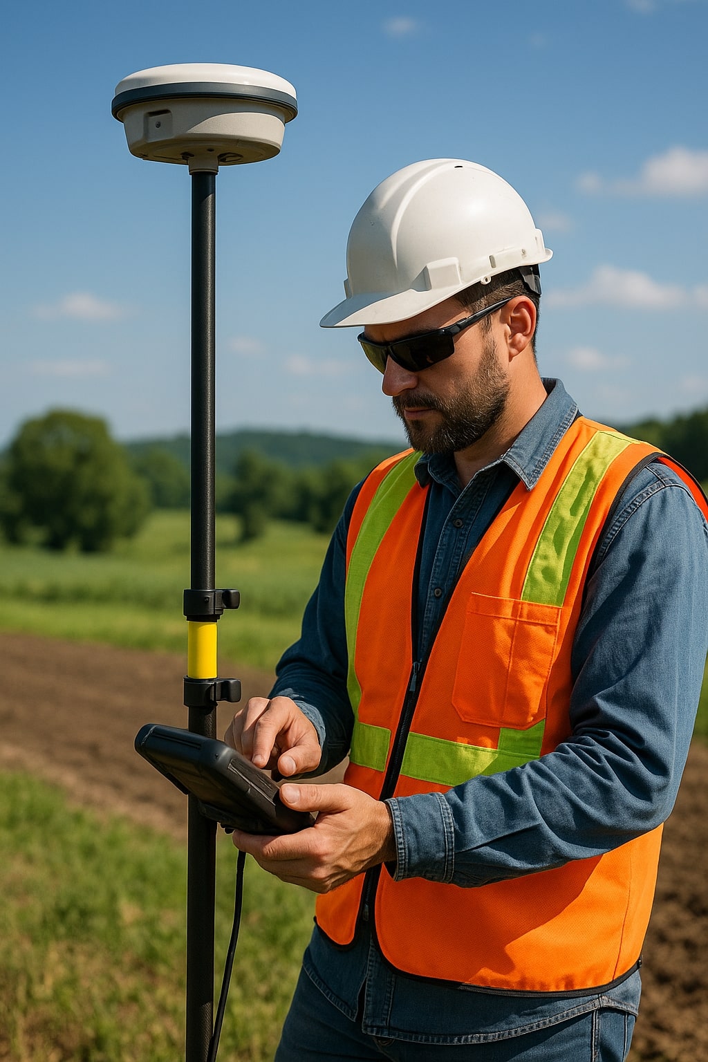
Unmatched accuracy in surveying
One of the main benefits of the GP in the land survey is its unique accuracy. Modern GPS receiver receiver can achieve precision at the centimeter level, which is important for projects such as road construction, property boundary, urban planning and mapping of tools. By eliminating human errors and environmental limits, GPS ensures that measurements are not only estimated but scientifically accurate.
In addition, the integration of differential GPS (DGP) and real -time kinmetics (RTK) positioning system has increased this accuracy to even higher levels. These advanced techniques allow the surveyors to fix satellite signal errors caused by atmospheric conditions, ensuring reliable results in complex projects. This high degree of accuracy is a gaming chain for industries that require accurate data of legal, engineering or safety reasons.
Speed and efficiency in project execution
Time building, real estate and infrastructure projects are money. Traditional survey methods can significantly delay projects, especially when covering large areas. With GPs, the surveyors can complete the tasks that take weeks even for a few days or hours. For example, a highway adjustment survey that was previously necessary manual measurements in several posts was now done quickly using GPS-based data collections.
In addition, GPS technology is initially integrated with a geographical information system (GIS) and digital mapping software. This allows surveyors to transfer data directly to digital platforms for immediate analysis, plan and decision -making. The combination of speed, accuracy and digital integration ensures that projects are distributed in time without compromising on quality.
Revolutionizing Remote and Large-Scale Surveys
One of the biggest challenges in the traditional survey was access. Remote external places, robust areas and extended lands often have logical obstacles. GPS has effectively eliminated these challenges. The surveyors can now map thousands of hectares of land without reaching every corner, as the GPS receiver can collect data anywhere within the satellite coverage area.
It has proven to be particularly useful in industries such as agriculture, forestry and mining, where studies with major compliance are needed. For example, agricultural surveys can use GPS to map irrigation systems, soil types and crop limits, while miners can quickly emphasize excavation areas with accurate measurements. This versatility makes GPS an indispensable unit in many regions worldwide.
Cost Savings and Resource Optimization
Implementation of the GP in the Land Survey not only saves time, but also reduces the total project cost. Smaller surveyors require a need for low time and minimum equipment, companies can effectively adapt to resources. Traditional methods often required a team of three to five people working in the sink, while GPS allows a single operator to receive the same with advanced equipment - if not better - results.
In addition, the accuracy of GPS reduces the risk of expensive errors. Incorrect surveys can lead to boundary disputes, delays in the construction or even structural faults. By ensuring accuracy from the beginning, GPS reduces the possibility of errors, and protects organizations from economic and legal errors in a long time.
Global Adoption and Future Trends
The effect of GPS technology is not limited to the same area - this is a global revolution in the land survey. GPS plays a central role in the design of the future of urban and rural landscapes, from developed countries to countries that expand infrastructure in countries that build smart cities. Governments and private organizations are investing rapidly in GLOSESSES (GLONSO, Glonas, Galileo and Beedo GLPS, including Glonas, Galileo and Beedo, as to ensure uninterrupted and improved global coverage.
Furthermore, the future of the land survey lies in the integration of GP with new technologies such as drones, AI and 3D mapping. Drone equipped with the GPS receiver can map huge areas, while analyzing GPS data for AI interest-Yojana. Together, these innovations are expected to make the survey even more efficient, durable and accessible.


