Geo Measure: The Smart Way to Measure Land Area & Distance Using GPS
Introduction
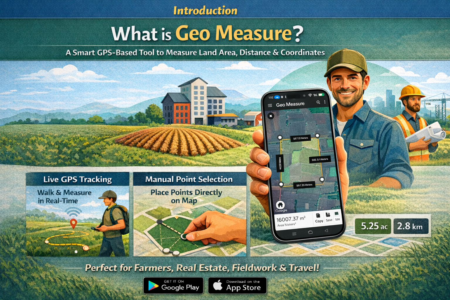
Geo Measure is a smart and easy-to-use GPS-based measurement tool that helps users accurately measure land area, distance, and location coordinates using interactive maps. Designed for simplicity and reliability, it allows measurements through live GPS tracking or manual point selection. Available on Android and iOS platforms, GeoMeasure is ideal for farmers, real estate professionals, field workers, and anyone who needs quick and accurate location measurements without traditional surveying tools.
1. What is Geo Measure?
Geo Measure is a smart GPS-based tool used to measure land area, distance, and geographic coordinates using interactive maps. It allows users to mark points manually or measure boundaries using live GPS tracking. Geo Measure works on Android and iOS platforms, making it easy to access anytime. It is designed for farmers, real estate professionals, field workers, engineers, and anyone who needs accurate location measurements without traditional surveying tools.
2. What is Geo Measure used for?
Geo Measure is used to calculate land area, measure distance between locations, and find GPS coordinates. It helps users measure farm fields, property plots, routes, and site boundaries accurately. The tool is useful for planning, estimation, documentation, and basic surveying tasks. With its simple interface and GPS support, GeoMeasure makes location measurement faster and more reliable.
3. How does GeoMeasure help in measuring land area using GPS?
Geo Measure uses live GPS tracking to record boundary points while the user walks around the land. These GPS points are connected on the map to calculate the total area automatically. Users can also place points manually if GPS is not required. The calculated area is displayed instantly in multiple units, such as acres, hectares, or square meters, making land measurement simple and efficient.
4. What is the advantage of using GPS for land measurement?
Using GPS for land measurement reduces human error and saves time compared to traditional methods. GPS allows real-time, on-site measurement without physical tools. It provides accurate results, works in large or irregular areas, and helps users measure land independently. GPS-based measurement is especially useful in agriculture, real estate, and fieldwork, where precision and speed are important.
5. Can Geo Measure be used for distance measurement between locations?
Yes, Geo Measure can measure the distance between two or more locations. Users can add points manually on the map or use GPS tracking to record an actual path. The tool calculates the total distance instantly in meters or kilometers. This feature is useful for route planning, road estimation, field inspections, walking paths, and travel analysis.
6. Does GeoMeasure support manual measurement without GPS?
Yes, Geo Measure allows manual measurement without GPS. Users can place markers directly on the map to outline an area or draw a path for distance measurement. This mode is useful when the GPS signal is weak or when users want to measure a location remotely. Manual mode offers flexibility while still providing accurate calculations.
7. What measurement units are supported in GeoMeasure?
Geo Measure supports a wide range of measurement units to suit different needs. Area can be viewed in square meters, square feet, acres, and hectares, while distance can be measured in meters and kilometers. This flexibility makes GeoMeasure useful for users across different regions and professions, allowing easy comparison and understanding of results.
8. Is Geo Measure free to use?
Yes, GeoMeasure is free to use and does not require any registration or login. Users can start measuring land area or distance immediately. The free access makes it ideal for individuals and professionals who need quick measurements without investing in expensive tools or software.
9. Is Geo Measure available on mobile devices?
Geo Measure is available on both the Google Play Store for Android devices and the Apple App Store for iOS devices. This cross-platform availability ensures users can measure land and distance anytime, whether they are in the field or working from an office.
10. Who can benefit from using GeoMeasure?
Geo Measure is beneficial for farmers, real estate professionals, civil engineers, surveyors, field workers, planners, and travelers. Anyone who needs accurate land area or distance measurements can use GeoMeasure. Its easy-to-use interface and GPS-based accuracy make it suitable for both professional and personal use.
Conclusion
Geo Measure is a reliable and user-friendly solution for measuring land area, distance, and GPS coordinates with accuracy and ease. By combining live GPS tracking with interactive maps, it simplifies location measurement for both professional and everyday use. Available on Android and iOS, Geo Measure eliminates the need for traditional surveying tools and saves time while delivering dependable results. Whether for agriculture, real estate, fieldwork, or travel planning, GeoMeasure offers a smart and efficient way to handle all your measurement needs.


