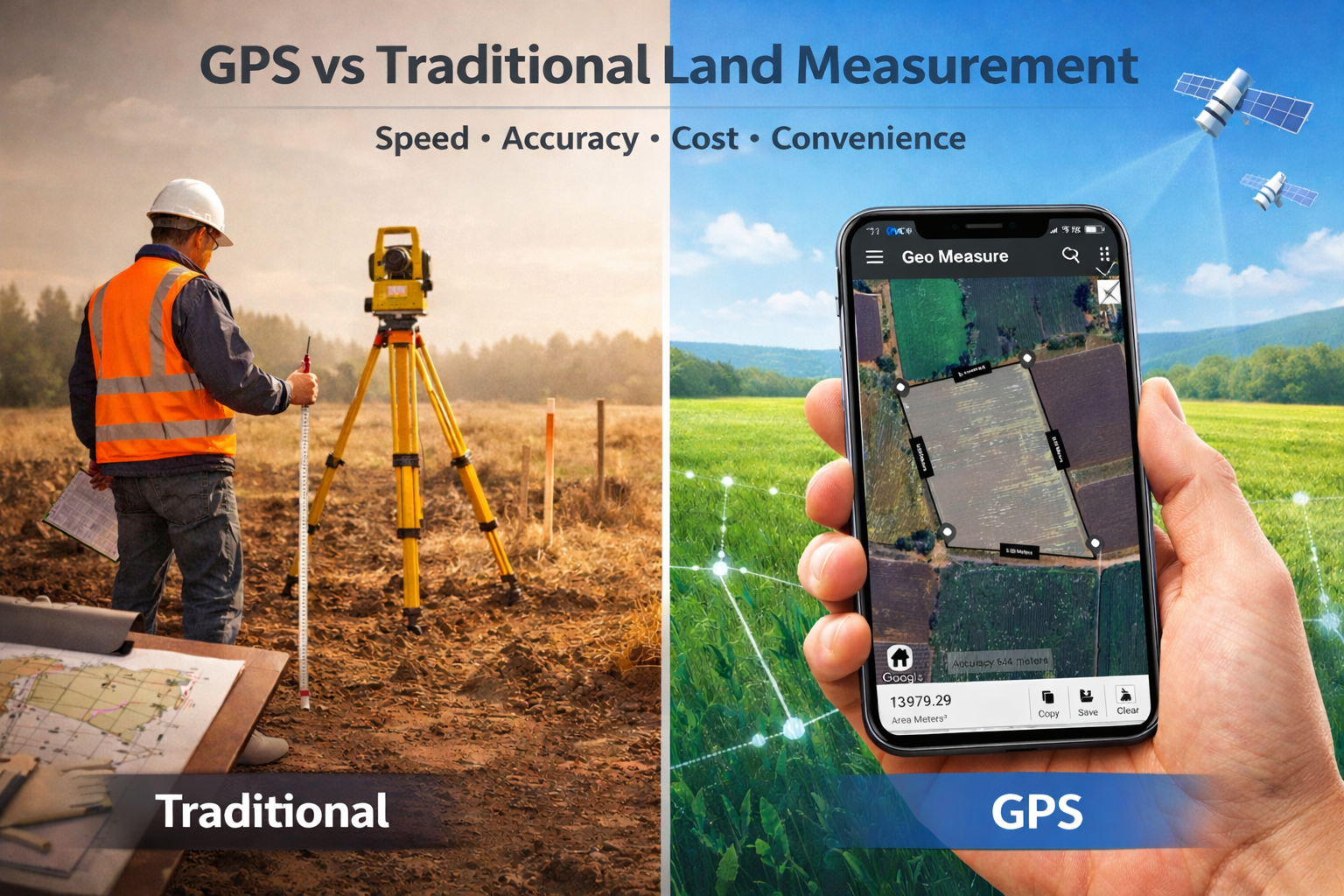
Why GPS Land Measurement is Better Than Traditional Methods
Measuring land accurately has always been essential for farmers, property buyers, engineers, and surveyors. For decades, traditional land measurement methods using tapes, chains, compasses, and theodolites were the only options. Today, GPS land measurement technology has transformed the way land area and distance are calculated, making the process faster, more accurate, and far more convenient.
In this article, we compare GPS land measurement vs. traditional methods and explain why modern digital tools are becoming the preferred choice worldwide.
What Is GPS Land Measurement?
GPS land measurement uses satellite-based positioning technology to calculate land area, perimeter, and distance. By marking points on a digital map or walking the boundary of a property with a GPS-enabled device, users can get real-time and precise measurements.
Unlike traditional tools, GPS measurement relies on satellite signals and digital mapping, removing much of the manual work and calculation errors associated with older techniques.
How Traditional Land Measurement Methods Work
Traditional land surveying methods involve physical tools and manual calculations. Common tools include:
-
Measuring tapes and chains
-
Compasses for direction
-
Theodolites for angle measurement
-
Survey poles and markers
Surveyors must physically measure distances and angles, record readings, and calculate land area manually or later using formulas. While effective, this process is time-consuming, labor-intensive, and more prone to human error.
Accuracy Comparison: GPS vs Traditional Surveying
One of the biggest advantages of GPS land measurement is improved accuracy with less effort.
Traditional Method Accuracy
Traditional methods can be accurate when handled by experienced professionals, but errors can occur due to:
-
Incorrect tape alignment
-
Uneven terrain
-
Misread angles
-
Calculation mistakes
GPS Measurement Accuracy
GPS tools reduce many of these issues by:
-
Using satellite positioning instead of physical alignment
-
Automatically calculating area and distance
-
Minimizing human calculation errors
Modern GPS land measurement tools provide reliable accuracy for most agricultural, real estate, and construction needs, especially when high-quality GPS signals are available.
Time-Saving Benefits of GPS Land Measurement
Traditional surveying can take hours or even days depending on land size and terrain. GPS measurement dramatically reduces this time.
With Traditional Methods:
-
Multiple people may be needed
-
Physical marking and measuring takes longer
-
Data must be manually recorded and calculated
With GPS Tools:
-
One person can often do the job
-
Measurements are calculated instantly
-
Results are stored digitally
This makes GPS land measurement ideal for farmers checking field size, real estate agents verifying plot area, and engineers planning sites quickly.
Cost Comparison: GPS vs Traditional Land Measurement
Hiring professional surveyors and using traditional tools can be expensive due to labor, equipment, and time requirements.
GPS measurement reduces costs by:
-
Eliminating the need for heavy equipment
-
Reducing manpower
-
Allowing property owners to measure land themselves
For many everyday measurement needs, GPS tools offer a cost-effective alternative while still maintaining strong accuracy.
Ease of Use and Accessibility
Traditional land surveying requires training and technical knowledge. GPS land measurement tools, on the other hand, are designed for everyday users.
Most GPS-based measurement apps and devices feature
-
Simple map interfaces
-
Tap-to-mark boundaries
-
Automatic unit conversion (acres, hectares, sq. ft., sq. meters)
-
Easy data saving and sharing
This accessibility allows non-professionals to measure land confidently without specialized equipment.
Better Data Storage and Sharing
Traditional methods rely on notebooks, sketches, and paper records that can be lost or damaged. GPS measurement tools store data digitally, making it easier to:
-
Save past measurements
-
Export land boundaries
-
Share maps with clients or teams
-
Revisit locations later
Digital storage improves record-keeping and supports better planning and communication.
Use Cases Where GPS Outperforms Traditional Methods
GPS land measurement is especially useful for:
Agriculture
Farmers can measure field area for crop planning, irrigation layout, and fertilizer estimation.
Real Estate
Buyers and agents can verify property size before purchase or listing.
Construction & Engineering
Engineers can quickly assess site dimensions for planning and layout.
Route & Distance Measurement
Users can measure distances between multiple points for travel, walking, or project planning.
When Traditional Surveying Is Still Needed
While GPS measurement is powerful, traditional professional surveying is still important for:
-
Legal boundary disputes
-
Government land registration
-
Large infrastructure projects requiring extreme precision
In these cases, licensed surveyors use advanced equipment for official documentation. However, for everyday land measurement, GPS tools are often more practical.
GPS Land Measurement vs Traditional Methods: Quick Comparison
| Feature | GPS Land Measurement | Traditional Methods |
|---|---|---|
| Speed | Instant results | Time-consuming |
| Cost | Low | High |
| Ease of Use | Beginner-friendly | Requires training |
| Equipment | Smartphone or GPS device | Survey tools & gear |
| Data Storage | Digital & shareable | Manual records |
| Accuracy | High for general use | High but skill-dependent |
Conclusion
GPS land measurement is quickly becoming the preferred method for measuring land area and distance. It offers faster results, reduced costs, improved convenience, and reliable accuracy for most practical needs. While traditional surveying still plays a role in legal and high-precision work, modern GPS tools provide a powerful solution for everyday land measurement tasks.
As technology continues to improve, GPS-based land measurement will only become more accurate, accessible, and essential.
Q1: Is GPS land measurement reliable?
Yes, GPS land measurement is reliable for most property, farming, and planning needs when good satellite signals are available.
Q2: Why is GPS land measurement faster than traditional methods?
GPS tools automatically calculate distance and area in real time, while traditional methods require manual measurement and calculations.
Q3: Can I measure my land without hiring a surveyor?
Yes, GPS measurement tools allow property owners to estimate land area themselves, though legal surveys may still require professionals.
Q4: What are the main benefits of GPS land measurement?
The main benefits include speed, lower cost, digital records, ease of use, and reduced human error.


