How to Get a Distance Between a Two GPS Coordinates?
GPS is also used for anything that you might need location services for, such as Land Surveying, search and rescue missions, measuring the distance between two places
The Global Positioning System (GPS), has been one part of our lives for the past 20 years. We just have to type or have to say where we want to go on our device and our device starts to plan a route for us in just a matter of minutes. We even adjust our routes to avoid traffic, tolls, and much more.
Maintained by the U.S. Space Force, GPS is made of 31 satellites that are in orbit at a distance of 20,200 kilometers that is approx 12,550 miles above the Earth.
In today’s era GPS is so accurate that it can be located in your position within 4.9 meters (16 feet), though in this advanced technology and using an additional signal and post-processing can increase GPS precision.
Once your device calculates your longitude, latitude, and altitude, it can create a one road map whatever company’s software you use. That map is what you see you go along with. A navigation service provider gives you updates about the traffic on your route and changes the perfect route for you.
GPS is also used for anything that you might need location services for, such as Land Surveying, search and rescue missions, tracking shipments, wildlife, measuring the distance between two places, area calculating, etc.

A smartphone is now all you need to quickly tackle the micro measurement task in a matter of minutes. Unfortunately, every distance measurement app is barely competent, there are dozens of applications available, and that are virtually useless. Just for you, we are waded knee-deep through the Google Play Store to bring you these best distance measure apps for Android and iPhone.
We recommend you to install all these apps just because they are all suited for different distance measurement scenarios and have different features. Every recommendation has different features and functionality so if one feature is not working you can use another one.

1. Geo Measure Area Calculator:
You might think that you have seen it all in the application at…
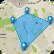
But, the Geo Measure Area Calculator app has more to offer you. As you can see the name states that the app could not only measure distance but also find areas of a lot.
How cool is that?
Now, this application allows you to measure your distance manually using either GPS.
To explain more about the manual measuring of the distance that lets you know the distance by simply plotting the points on the Map, on the other hand, the GPS Measuring will calculate the distance or area as you run or walk through a path.
Check out the below steps to know how GPS Distance actually works
- Open app Geo Measure Area calculator FREE
- Click on the PLUS button on the right-bottom, you will find two options there i.e. Distance and Area.
- Choose the appropriate option and you will get two new options to choose i.e. (i) Manual measurement and (ii) GPS measurement.
- Choose the first option (ii) GPS measurement. and the app will give you the option to record your current GPS position.
- You can find that option Start recording on TOP of MAP. Once you click on the Start recording application will start recording your current position.
- Now you simply need to move around at the location of which you want to calculate area or distance.
- You can click on Stop recording once you complete your measurement.
- Hence the application is recording your location based on your GPS position and you don’t need to specify your location manually, that’s why we called this feature GPS measurement


Download Geo Measure App Now:
Android Phone / Tablet: https://goo.gl/ZwGz76
iPhone/iPad /iPod Touch: https://goo.gl/z8V7eo
Amazon Store: https://byrl.me/geo-measure-app
Mac App Store: https://byrl.me/zUjCuhQ
Visit Geo Measure site: https://geomeasure.in/

2. GPS Fields Area Measure
This is probably the most commonly-known app mentioned here. The GPS Fields Area Measure is a free land survey app to download and is the best app to start surveying land on smartphones. It features a simple and well-designed interface where users can find hundreds of GPS options in the app.
Play Store: Download App
3. GPS Land Area Calculator
If you are not willing to spend money on a GPS land survey app then the GPS Land Area Calculator is enough to help you. The app is straightforward and has all the required options that can help you to calculate the land area.
Users can make use of a variety of features of this app from anywhere and at any time. It gives the option of map, satellite, terrain, and hybrid modes view. Users can also use the area search tool to search any particular area.
Play Store: Download App
Conclusion:
I think we all agree when I say technology is unstoppable, it’s everywhere!
These apps that measure distance and give accurate results are to be sure, I would like to recommend you to install these all and check their unique features.
Popular Articles To Read
| Geo Measure Area Calculator - Area Measured By Drawing Custom Path
| Augmented Reality (AR) - A Game Changer For Mobile Apps in 2021
| Measure Your Land In One Minute
| Top Augmented Reality App Development Company In Rajkot, Gujarat, India
| How To Calculate Area And Distance On A MAP


